Quantcast
Channel: Travis Roberts – Precision Doppler
Viewing all 17 articles
Browse latest View live

Travis Roberts Checking In

$
0
0

Hello everyone!  Thanks for reading our blog here at WVVA.  Since this is my week to post to the weather blog, I wanted to use this post to introduce myself and share some of my thoughts.

I am originally from the Tazewell, Virginia area, and continue to call Four Seasons Country, home.  My wife and I have two children and they keep us very busy.   Before coming to WVVA, I ran a video production business and also worked for a local ministry.  I graduated from Bluefield College with a B.A. in Communications and am continuing my weather education, currently completing Meteorology courses with Mississippi State University.


WVVA’s Stan Sweet and 10-Year old Travis Roberts

I have  had a passion for weather forecasting since I was in second grade.  Before I turned 11, I had already learned a few forecasting tricks from former WVVA weather anchor Stan Sweet.  I also became a National Weather Service storm spotter while still in grade school.  The picture posted here of Stan and I was at the NWS Storm Spotter training at WVVA in 1989.  Weather was something that fascinated me, and to this day continues to amaze and challenge me.

Growing up and working on a dairy farm in Tazewell County, I learned how weather can make or break your day.  Work on the dairy farm was often slowed, thanks to the sub-zero winter cold that Burkes Garden is known for.  In addition, corn planting and harvesting, hay baling and other farm activities revolved around the weather conditions.   Working outside in the weather gives you a real appreciation for receiving an accurate forecast.

We’re all affected by the weather.  My goal as a member of the WVVA Weather Team is to provide accurate, informative and helpful information to help you plan.

I look forward to future blog posts on a variety of topics. One final item that I want to share.  I enjoy photography, especially weather and star photography.  Here is a slideshow of a few images I’ve been able to capture over the last few years.

Spring Storm Lightning Lightning at Night during a back-building thunderstorm. The Milky Way seen from Burkes Garden, VA Popup Showers in the summer, seen from Mt. Rogers National Recreation Area. Solar Eclipse, Fall 2014 Fog over Wythe County, VA Hungry Mother State Park, Fall 2014 Comet Pan-STARRS Sunset Lightning during an evening summer thunderstorm


Common Winter Precipitation Setups

$
0
0

In my opinion, winter in the Two Virginia’s is the most interesting season to forecast. In this post, I’m going to briefly highlight typical winter weather setups that we’ll probably see again this year.

 The Miller A (The Classic Snowstorm)

This is by far, the most powerful type of snowstorm that we see in this area. These storms form along the Gulf Coast and work northeast (becoming powerful noreasters) along the eastern seaboard of the United States. We often see copious amounts of snow with these types of storms and they usually end with upslope snow showers as the low pulls away and draws in a strong northwest flow. The most memorable storm of this type was the 1993 Superstorm that crushed the WVVA viewing area with feet of snow.

 Cold Air Damming (Ice)

Cold air has a greater density than warm air. When an area of low pressure moves just to our west, warm air is drawn north and east across our area. When a strong arctic high is in place, the cold air at the surface is slow to erode away. In fact, sometimes the arctic high is strong enough to continue feeding cold air south and east along the eastern slopes of the Appalachian Mountains. This cold air can bleed all the way into northeastern Georgia if the high is strong enough. When this happens, we often see a mixed bag of precipitation.

Locations in the western viewing area from Western Tazewell County, McDowell County and Wyoming County, often warm the fastest and sometimes only see rain. Eastern counties, such as Greenbrier, Monroe and Giles are often deeper in the cold air, and see a prolonged period of frozen precipitation.   These types of weather setups also typically drive a strong southeasterly wind into the area. High winds are often felt along the western slopes. Strong down sloping winds often blow in Mercer and Tazewell counties, especially in proximity to East River Mountain.

The Alberta Clipper

Fast moving systems that originate in the Canadian prairies (hence the Alberta clipper name) move southeast bringing a quick shot of snow. While snowfall amounts with these systems are generally light (usually 2-5 inches), they are very common. You can bet that we’ll see a few of these this year.

Upslope and Lake Effect Snow

Yes, we do get lake effect snow this far south. When wind trajectories are just right, moisture feeds south from the great lakes and is lifted over our mountains. Snowfall amounts vary widely across the WVVA viewing area with these types of snow events. Western slopes generally see the most, as orographic lift squeezes moisture out of the atmosphere as air rises and crosses over the mountains. Western Greenbrier County and Pocahontas County receive on average the most snow from these snow events. Sometimes these areas can receive up to a foot of snow, while other areas may only have a dusting.

Spot the International Space Station

$
0
0
International Space Station

International Space Station

Several weeks ago I mentioned during a newscast that the International Space Station would be passing overhead. I was pleasantly surprised by the positive viewer feedback I received from people watching. If you have never been able to track and watch the space station pass overhead on a clear night, then you need to make plans to see it!

The best way to ensure you see the space station is to be exactly sure when it is going to pass overhead and where to look.

Find out when it will pass here: http://spotthestation.nasa.gov

The space station doesn’t cross over the exact same area as it orbits the planet. I personally have spotted the station as it moves north across our hemisphere and back south toward the southern hemisphere.

Shot I took of the ISS. This is a 10 second exposure, creating the streak.

Shot I took of the ISS. This is a 10 second exposure, creating the streak.

Typically the window of opportunity to see the space station will be just after sunset and before sunrise. This is because the space station has not passed into darkness (or experienced sunset) at around 220 miles above our heads. It will appear as a steadily moving, often bright star. There are no lights visible on the space station, so any blinking lights you spot will be aircraft.

You may also spot other satellites crossing the sky. That’s why it’s very important to know exactly what direction to look and when.

According to NASA’s website, “the space station, including its large solar arrays, spans the area of a U.S. football field, including the end zones, and weighs 924,739 pounds. The complex now has more livable room than a conventional six-bedroom house, and has two bathrooms, a gymnasium and a 360-degree bay window.”

Now get out there, and check it out!

A Few Cold Weather Lifehacks

$
0
0

Weather ChangeWith the arrival of bitterly cold air, I wanted to share a few “cold weather lifehacks” that I have found helpful.

1. Dress for the weather

Typically when air temperatures are expected to be below 20, I dress in layers.  Even if I am working in the studio, I will wear two pair of pants (usually a pair of athletic pants for the bottom layer).  Even if you are working indoors, layering up makes those trips from the car to the front door much easier. Plus, if you have an emergency on the road, you will be better prepared for cold weather exposure.   Dressing in layers also better insulates your body from the cold.   Layers create air gaps between clothing articles, enhancing the ability to stay warm.

2. Ski Goggles

I love to snow ski and have been a skier all my life.  A few years ago, I started wearing an elastic face mask when I had to go outside in near zero temperatures.  During one extreme cold weather event, I decided to throw on the goggles.  Now whenever temperatures drop near zero and I need to go outside to plow the driveway or do any other outside work, the goggles go on.  You can get an inexpensive pair for around $20 or $30.  I know that I’ll be pulling mine out this weekend!

3. Park Facing the Sun

If you leave home in the morning after the sun rises, harness that solar energy to melt your windshield. This is not only good during extremely cold weather, but also great for regular frosty mornings.  Park your car (if you have the ability) facing southeast.  The sun doesn’t rise due east during the winter months.  Instead, because of the lower sun angle, it rises just south of east.  Pointing your car southeast will allow more direct sunlight exposure to your windshield as the sun rises. Keep in mind, if buildings, trees or other obstacles block direct light from the sun, this will not work.

Winter weather is full of surprises.

Winter weather is full of surprises.

4. Pay Attention to Weather Forecasts

This sounds trivial, but cannot be overlooked.  A few years ago just after a snowstorm that dumped over 12 inches of snow, a friend told me he never saw it coming.  This storm was well advertised, was headline news, was on the front page of every newspaper and was injected into almost every conversation on the streets.  Simply knowing what is coming the next day makes preparing much easier.

5. Know How to Cut Off Main Water Supply

If your pipes freeze and burst, would you know how to turn off the main water supply to prevent major property damage? Recently a pipe in the ceiling over my living room began leaking out of the blue.  I awoke in the middle of the night to the sound of water dripping and running.  Thankfully I was able to catch this leak and prevent any major damage.    The best way to fight freezing pipes is to prevent them from freezing.  Insulate pipes, leave cabinet doors open and you may need to leave faucets dripping.


Calling all Weather Enthusiasts

$
0
0

Generally after a strong storm, heavy snow or even a beautiful sunset, our WVVA Weather Facebook page starts to fill up with viewer submitted photos and weather reports. Thank you so much for sharing what you see out there.

Your reports help, especially during complex weather situations where just a few miles and a few degrees on the thermometer mean the difference between a cold rain and heavy wet snow.

The National Weather Service also utilizes reports from the public in severe weather situations. Often at the end of a weather bulletin message, a phone number and website is given, encouraging severe weather reports from the public.

Travis Roberts at a NWS storm spotter training with WVVA's Stan Sweet

Travis Roberts at a NWS storm spotter training with WVVA’s Stan Sweet

This spring, the National Weather Service in Blacksburg is training Skywarn spotters. When I was only 10 years old, I became a storm spotter after completing training at WVVA.

We will be hosting a SKYWARN® training class at the WVVA studios on Monday, April 6th from 7pm to 9pm. You have to sign up to attend, so email weather@wvva.com with your name, phone number & how many will be attending! The class is limited to 50 individuals, so sign up fast!

The following information is from the National Weather Service website regarding the SKYWARN® program. (nws.noaa.gov/skywarn)

NOAA’s National Weather Service (NWS), part of the U.S. Department of Commerce, established SKYWARN® with partner organizations. SKYWARN® is a volunteer program with nearly 290,000 trained severe weather spotters. These volunteers help keep their local communities safe by providing timely and accurate reports of severe weather to the National Weather Service.”

Although SKYWARN® spotters provide essential information for all types of weather hazards, the main responsibility of a SKYWARN® spotter is to identify and describe severe local storms. In the average year, 10,000 severe thunderstorms, 5,000 floods and more than 1,000 tornadoes occur across the United States. These events threatened lives and property.

For Weather Enthisiasts

If you are a weather enthusiast like me, this is a great opportunity to learn more and help your community!

Here is a flashback video of me giving one of my first weather reports at at 10 years old.  Every evening at this age I would watch the 6pm weather forecast and hand-draw a surface map on my trusty chalkboard. I was, and remain an enthusiast…to say the least!


It’s Spring Forest Fire Season

$
0
0
Firefighters working a brush fire in Bland County, VA on March 31, 2015.

Firefighters working a brush fire in Bland County, VA on March 31, 2015.

Last week I covered a brush fire in Bland County that was quickly controlled thanks to the efforts of several county fire departments. It is the time of year when brush fires can easily get out of control quickly under the right conditions.

According to the Virginia department of Forestry: “Since forest fuels cure during the winter months, the danger of fire is higher in early spring than in summer when the forest and grasses are green with new growth.”

Dry air can enhance fire danger

Dry air can enhance fire danger

When strong winds, low relative humidity and warm afternoon spring temperatures combine with the dried fuel, a high fire danger exists.

When a high danger of fire exists, the National Weather Service issues Red Flag Warnings.  A Red Flag Warning was in effect while the fire in Bland County was burning.  Very strong winds allowed the fire to spread quickly.   One firefighter was treated for smoke inhalation and a hay barn was burned to the ground.  Thankfully, no other serious injuries or property damage took place.

Remember that if Red Flag Warnings are issued, refrain from any outdoor burning.

According to the NWS, a Red Flag Warning is: A term used by fire-weather forecasters to call attention to limited weather conditions of particular importance that may result in extreme burning conditions. It is issued when it is an on-going event or the fire weather forecaster has a high degree of confidence that Red Flag criteria will occur within 24 hours of issuance. Red Flag criteria occurs whenever a geographical area has been in a dry spell for a week or two, or for a shorter period , if before spring green-up or after fall color, and the National Fire Danger Rating System (NFDRS) is high to extreme and the following forecast weather parameters are forecasted to be met:
1) a sustained wind average 15 mph or greater
2) relative humidity less than or equal to 25 percent and
3) a temperature of greater than 75 degrees F.

In some states, dry lightning and unstable air are criteria. A Fire Weather Watch may be issued prior to the Red Flag Warning.

As for outdoor burning laws, here is what is currently in effect.

Virginia

The 4:00 p.m. Burning Law states: from February 15 through April 30 of each year, no burning before 4:00 p.m. is permitted, if the fire is in, or within 300 feet of, woodland, brushland or fields containing dry grass or other flammable material.

West Virginia

West Virginia’s spring forest fire season started March 1, 2015, and runs through May 31, 2015. During these three months, daytime burning is prohibited from the hours of 7 a.m. to 5 p.m. Outdoor burning is permitted only between the hours of 5 p.m. and 7 a.m.

State law requires a ring or safety strip around outdoor fires to keep the fire from spreading into the woods. This safety strip must be cleared of all burnable material and be at least 10 feet wide completely around the debris pile.

Additional requirements of the state’s fire laws include staying on-site until the fire is extinguished and burning only vegetative materials like leaves, brush and yard clippings.

It is stargazing season!

$
0
0
You can leave the coats inside now that warmer weather is here!

You can leave the coats inside now that warmer weather is here!

The weather is getting warmer and people are spending more time outdoors. Spring and summer is a great time of year to enjoy evenings and nights outdoors under the stars. In this blog post I am going to talk about a few things that you can do to make your night adventures this summer more interesting!

What are you looking at?

Occasionally people will stop and ask me about a particular bright star they may have seen in the sky. Now thanks to a variety of websites, it’s easier than ever to figure out what you’re looking at in the night sky. One of the best tools that I use on a regular basis is the app “Google SkyMap.” You can simply install the app on your phone and move your phone toward the star or planet you are interested in. It is a great tool for scanning the sky to see what is available for viewing.

https://play.google.com/store/apps/details?id=com.google.android.stardroid&hl=en

Light pollution on the horizon

Light pollution on the horizon

Is it dark enough?

Light pollution from street lights and other lights in and around towns is the biggest obstacle to overcome when trying to view the night sky. Light from towns and cities shines into the atmosphere and is reflected back, creating a “hue” in the sky. Get away from the city lights for the best views.

What can you see?

There are some neat things to see in the sky that don’t require much more than a simple pair of binoculars. Depending on the time of year and position of the plants, you can see the moons of Jupiter. They look like tiny dots directly around and beside our solar systems largest planet. The Orion nebula is an area of glowing hot gas located in the constellation Orion. Another item that will come into view in the evening sky by late summer is the core of the Milky Way. In the spring it is located in the southern sky in the morning hours, but it will begin to rise earlier in the night as summer progresses.

The International Space Station is visible as sunlight is reflected off of its surface back toward the earth. You can track the space station and get tips to see when it will be available for viewing at:

http://spotthestation.nasa.gov/

Summer Lightning Safety

$
0
0
A bold of lightning I captured on camera near Tazewell, VA

A bold of lightning I captured on camera near Tazewell, VA

According to the National Weather Service, lightning kills on average 49 people in the United States each year, and hundreds more are injured. As we enter the summer months, we are starting to see more thunderstorm activity. Many days these storms pop up in the humid airmass that often resides across our area without much warning. Here are a few things you can do to stay safe this summer when lightning becomes a threat.


Lightning Strike Video

Lightning tips via the National Weather Service

Lightning: What You Need to Know

  • NO PLACE outside is safe when thunderstorms are in the area!!
  • If you hear thunder, lightning is close enough to strike you.
  • When you hear thunder, immediately move to safe shelter: a substantial building with electricity or plumbing or an enclosed, metal-topped vehicle with windows up.
  • Stay in safe shelter at least 30 minutes after you hear the last sound of thunder.

Indoor Lightning Safety

  • Stay off corded phones, computers and other electrical equipment that put you in direct contact with electricity.
  • Avoid plumbing, including sinks, baths and faucets.
  • Stay away from windows and doors, and stay off porches.
  • Do not lie on concrete floors, and do not lean against concrete walls.

Last Resort Outdoor Risk Reduction Tips

If you are caught outside with no safe shelter anywhere nearby the following actions may reduce your risk:

  • Immediately get off elevated areas such as hills, mountain ridges or peaks
  • Never lie flat on the ground
  • Never shelter under an isolated tree
  • Never use a cliff or rocky overhang for shelter
  • Immediately get out and away from ponds, lakes and other bodies of water
  • Stay away from objects that conduct electricity (barbed wire fences, power lines, windmills, etc.)

Hazards Tropical Systems Produce in the Two Virginias

$
0
0

Here in the two Virginias, we feel the effects of tropical systems that make landfall somewhere in the United States almost every year. When I say effects, I am referring to residual moisture that moves across our area after a landfalling tropical system gets swept along in the westerlies or sometimes the effect is more direct. Some systems stay organized enough to impact our weather in a major way.

The center of cirrculation from bill passed to our north, dry air also moved in from the southwest, limiting rainfall.

The center the remains of Bill passed to our north, dry air also moved in from the southwest, limiting rainfall.

This past weekend, the remenants of Tropical Storm Bill passed to our north after maintaining strength and structure thanks to very supportive upper level wind conditions and very moist soil across the centeral United States (some studies show that Bill may have actually continued to pick up energy from the warm and moist soil, much like a tropical system pulls energy from a warm ocean surface).

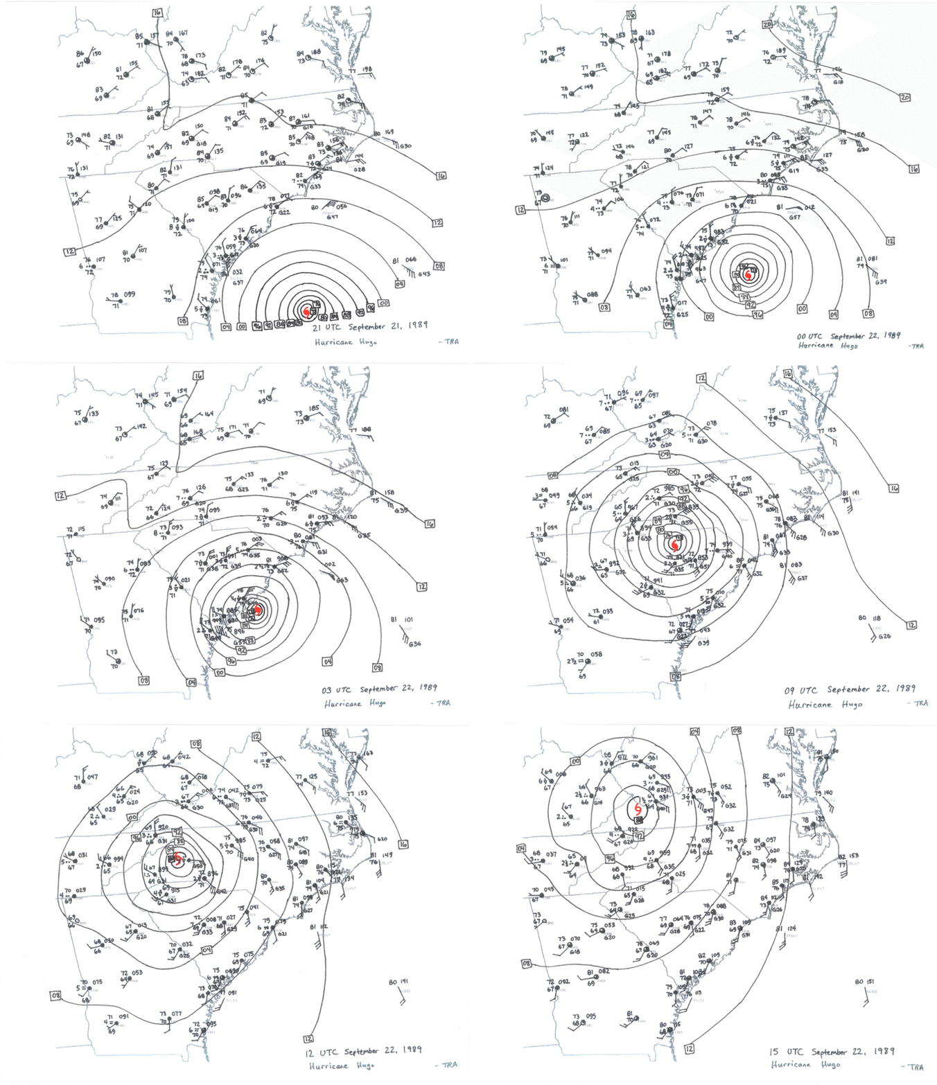
Hurricane Hugo

Because we are located several hundred miles from the ocean, even major hurricanes weaken signifigantly before reaching us. However we are not completely out of the danger zone. In 1989, hurricane Hugo struck Charleston, SC and moved directly northwest toward Bluefield. I clearly remember this storm and it’s intensity; trees were destroyed, buildings were damaged and flooding took place. In fact, Hugo was still classified as a tropical storm as the tropical system moved across our area.

Flooding from Camile

Major flooding after nearly 30 inches of rain fell from Camile in VirginiaWhile wind damage is a threat, flash flooding as a result of torrential tropical rains that get squeezed out of the atmosphere as air is lifted over our beautiful mountains is much more of a natural hazard. In 1969, hurricane Camile made landfall along the gulf coast of Texas and caused major flooding in the Blue Ridge Mountains of Virginia. 153 people lost their lives in Virginia due to some areas receiving 30 inches of rain. That over 2.5 feet!!!

This is from the National Weather Service flood safety website:

While Hurricane Camille will long be remembered for the catastrophic damage it produced along the Gulf coast, the inland flooding will long be remembered in Virginia. Two days after making landfall, Camille had been downgraded to a tropical depression and turned east from the Ohio Valley into the Central Appalachians. During the evening of the 19th, Tropical Depression Camille began to interact with a very humid late summer air mass over central and western Virginia along with a stalled east to west oriented frontal boundary. This combination of factors, along with the higher terrain in the Blue Ridge Mountains, produced continuous thunderstorms from late in evening on the 19th through the morning hours on the 20th. The heaviest rain fell across Rockbridge, Amherst and Nelson counties, where rainfall totals of 10 to 30 inches were reported.”

What are the “Dog Days of Summer?”

$
0
0

The dog days of summer are here, but what exactly are they? I once thought that dog days were given the descriptive name because it was too hot, even for dogs to leave cool areas.

Hubble Space Telescope image of Sirius, the "Dog Star." photo: NASA

Hubble Space Telescope image of Sirius, the “Dog Star.” photo: NASA

The dog days of summer were actually recognized by ancient Greek civilizations. In late July, the star Sirius and the constellation Canis Major begins to rise in the morning sky. The Greeks actually thought that it was the “dog star” Sirius that caused the hot weather that also impacts the Mediterranean Sea area.

The Greeks and other cultures recognized the dog days of summer as being from around July 23rd until August 23rd. This is typically the hottest time of the year for many locations in the northern hemisphere.

The suns most intense rays actually strike the northern hemisphere during the summer solstice in late June. By August, the suns rays have lowered in intensity. Late July and early August is still the hottest time of year because there is generally a lag of 1-2 month lag in the seasons. That’s because it takes time for the atmosphere to warm in the summer and cool off in the winter.

You may have also noticed that the daylight hours are getting shorter, and that the sun is lower in the sky at high noon. We’ve already started the move toward fall celestially. Our temperatures are soon to start cooling off as less solar radiation is absorbed here in the northern hemisphere.

Get out and enjoy what is left of the Dog Days of Summer!

Fall Colors Arriving Soon

$
0
0
Higher elevations change colors first.  Notice the green trees in the valley below.

Higher elevations change colors first. Notice the green trees in the valley below.

Fall is about to officially begin, and it won’t be long until the leaves start changing colors. The weather plays a big part in how vivid fall colors are and how long they last. For example, a summer drought may cause a tree to lose it’s leaves early. Likewise an early frost or freeze can damage leaves and cause them to fall off. Strong winds can also blow leaves off of trees faster, reducing the duration of fall color.

But what causes the leaves to change color? According to NOAA, there are actually four primary pigments that produce color within a leaf. During the growing season, leaves produce chlorophyll which is green. As the days get shorter, trees begin to shut down for the winter. They also stop producing chlorophyll. As the green fades away, a leaves true colors begin to show.

Fall colors

Fall colors

We have had a fairly dry late summer, and that may have some impact on fall foliage. However we are also experiencing prime conditions that help cultivate vibrant colors. According to the United States Arboretum, a dry fall along with sunny days and clear and cool frostless nights result in the brightest colors.

Fall colors will be here before you know it. I hope you are able to get out and enjoy the leaves this year!


What is your favorite season?

$
0
0

Normally when I post on our weather blog, I break down a topic or talk about a weather subject.  In this post, I want to talk about why I believe fall is the best time of the year in our area.  Much of the subject matter in this post is a matter of opinion, but that’s what blogging is all about, right!?

10849021_10208127487725140_8374040591236184635_oDry Weather - Typically Fall is when we receive the lowest amount of precipitation.  As we start to see more influence from the westerlies, the tropical airmass that typically resides over the southeastern US begins to erode and is suppressed to our south.  Dry continental air from Canada helps to suppress popup afternoon showers and thunderstorms and often we see several days in a row of nice weather.  Warm sunny days and clear/cool nights are common in September and October.


1462772_10205152266866478_138894994972476422_oFall Colors - I think many of us take for granted the beautiful colors that we are able to enjoy each year.  I spoke with several people from North Carolina visiting the area last week.  They were in awe of the views.  While trees do change color in the Piedmont area of North Carolina, you generally only see trees that are close to you.  I have compared driving through a forest in an area that has flat topography equivalent to driving through a “tunnel of trees.”  You only see what is a few hundred feet away.


467588_3458316696855_1649825556_oWinter is on the Way - When I was younger, winter was my favorite season.  Looking back, I think that was mostly due to the possibility that snow may have kept me out of the classroom! I still love winter and have been an avid skier for 23 years.  For skiers, the changing leaves are a sure sign that the slopes will soon be covered with snow once again.

Although fall officially lasts through December 21st, meteorological fall ends on November 30th.   We still have several warm days left before snow starts flying, so get out and enjoy the beautiful fall conditions.


What is the Polar Vortex

$
0
0

The polar vortex is a permanent broad area of low pressure in the upper atmosphere near the poles. It is located a few miles above the surface of the earth and can be as large as the US and Canada combined. The polar vortex is not new, it is not a storm and doesn’t “hit,” but does influence our weather.

In the winter, it gets colder at the north pole, creating a strong temperature difference between the north pole region and the mid-latitudes. That temperature difference strengthens the vortex that spins around the pole.

A strong polar vortex often means warmer weather for us. That’s because the cold typically stays locked near the north pole due to a stronger jet stream/westerlies that create a barrier between us and the cold arctic air to our north.

When the vortex weakens, the upper atmosphere warms near the poles and the vortex sometimes “splits” and a chunks of the cold air moves south.  As the polar jetstream becomes more “wavy” due to a weaker polar vortex, cold air can dip further south.

So don’t expect to go outside and see a polar vortex heading for your house, but you will likely feel the effects of it as we do every winter. Stay toasty my friends.

Why humid air feels hotter

$
0
0

As we approach summer, you’ll hear us begin to talk more about how moisture content in the atmosphere make it feel warmer than it really is. If the temperature outside is 85 degrees, it will feel hotter if it is more humid. This is because evaporation is slower when the air is closer to being fully saturated.

Evaporation is a cooling process. When you get out of a pool, you feel cold. That’s because as water on your skin changes phase from a liquid to a gas, energy is absorbed by the water vapor during the phase change.

Dry and unsaturated air allows for rapid evaporation and faster cooling. Humid and more saturated air causes evaporation to take place at a slower rate, causing less cooling. Adding a breeze can enhance the evaporation process as well.

If you visit a pool after a cold front has moved through and a cool and dry Canadian airmass is in place, you’ll feel the rapid evaporation effect on your skin once you get out of the water. You’ll either want to get back in the water to stop the evaporational cooling or grab a towel to get the water off and end the chilling effect.

So the bottom line is that it feels hotter on humid days because moisture that is always on the surface of your skin cannot evaporate efficiently. When the air is dry, that moisture evaporates faster and you feel cooler. We can speed up the evaporation effect by pushing more air molecules past our skin.  That’s why a gentle breeze or a fan helps to battle hot conditions.

Rays of light after sunset in the summer sky

$
0
0


Crepuscular rays over Tazewell County (Photo: Travis Roberts)

Brilliant rays of light are sometimes visible in a clear blue sky in our area during the summer months after sunset. These are sometimes called sunbeams, but are officially known as crepuscular rays.

These unique optics are caused by clouds over the horizon casting a shadow. They are often seen in the warmer months of the year when towering cumulus clouds form.

They can often be seen at sunset and are created as the taller cumulus clouds block sunlight. Particles in the atmosphere reflect light that we see, but the shadow is causing part of the sky to not be illuminated.

If you see a neat weather event, snap a picture and send it to the WVVA Weather Team of Facebook or Twitter. We’d love to share your picture with our viewers!


Why valleys get colder on some nights

$
0
0

Cold air settles into low spots on a calm morning

On clear and calm nights, we often talk about how deep and sheltered valleys will likely be colder than ridges.  These common fall and winter conditions makes for a tricky forecast, with a wide range of low temperatures in the early morning hours.

Valleys get colder than surrounding ridges on clear and cold nights because an inversion sets up. This is where the air near to the ground get colder than air above it. This happens because on clear nights with light winds, the ground loses heat through radiational cooling.  The heat radiates out as longwave radiation and escapes into outer space.   This causes the air closest to the ground to cool rapidly.

On a calm night with light winds, the colder air drains into lower areas like valleys.  This is because of density differences between the very cold air near the ground and relatively warmer air above it. Sometimes you can see colder air that has drained  into valleys via fog.  The colder air in the valley cools and reaches the dewpoint. This is when air becomes completely saturated and condensation takes place, creating the fog you see.  You can also sometimes see frost in lower valleys while hillsides remain above freezing.

Sometimes a southerly wind flow above the surface can also develop.  The warm air rides up and over the colder air in the valleys at night.  Ridgetops often warm much faster than valleys with this setup. When this takes place, I’ve seen temperatures below freezing in valleys while high elevations are in the 50s.

So get ready, it is the season for clear and calm nights with wide temperature ranges.


A Few Cold Weather Lifehacks

$
0
0

Weather ChangeWith the arrival of bitterly cold air, I wanted to share a few “cold weather lifehacks” that I have found helpful.

1. Dress for the weather

Typically when air temperatures are expected to be below 20, I dress in layers.  Even if I am working in the studio, I will wear two pair of pants (usually a pair of athletic pants for the bottom layer).  Even if you are working indoors, layering up makes those trips from the car to the front door much easier. Plus, if you have an emergency on the road, you will be better prepared for cold weather exposure.   Dressing in layers also better insulates your body from the cold.   Layers create air gaps between clothing articles, enhancing the ability to stay warm.

2. Ski Goggles

I love to snow ski and have been a skier all my life.  A few years ago, I started wearing an elastic face mask when I had to go outside in near zero temperatures.  During one extreme cold weather event, I decided to throw on the goggles.  Now whenever temperatures drop near zero and I need to go outside to plow the driveway or do any other outside work, the goggles go on.  You can get an inexpensive pair for around $20 or $30.  I know that I’ll be pulling mine out this weekend!

3. Park Facing the Sun

If you leave home in the morning after the sun rises, harness that solar energy to melt your windshield. This is not only good during extremely cold weather, but also great for regular frosty mornings.  Park your car (if you have the ability) facing southeast.  The sun doesn’t rise due east during the winter months.  Instead, because of the lower sun angle, it rises just south of east.  Pointing your car southeast will allow more direct sunlight exposure to your windshield as the sun rises. Keep in mind, if buildings, trees or other obstacles block direct light from the sun, this will not work.

Winter weather is full of surprises.

Winter weather is full of surprises.

4. Pay Attention to Weather Forecasts

This sounds trivial, but cannot be overlooked.  A few years ago just after a snowstorm that dumped over 12 inches of snow, a friend told me he never saw it coming.  This storm was well advertised, was headline news, was on the front page of every newspaper and was injected into almost every conversation on the streets.  Simply knowing what is coming the next day makes preparing much easier.

5. Know How to Cut Off Main Water Supply

If your pipes freeze and burst, would you know how to turn off the main water supply to prevent major property damage? Recently a pipe in the ceiling over my living room began leaking out of the blue.  I awoke in the middle of the night to the sound of water dripping and running.  Thankfully I was able to catch this leak and prevent any major damage.    The best way to fight freezing pipes is to prevent them from freezing.  Insulate pipes, leave cabinet doors open and you may need to leave faucets dripping.


Viewing all 17 articles
Browse latest View live


Latest Images